Disturbance Study
Methodology to Assess Mining-Related Land Disturbance
In the summer of 2023, the Prospectors & Developers Association of Canada (PDAC) and the Mining Association of Canada (MAC) launched the Methodology to Assess Mining-Related Land Disturbance study.
This study presents a methodology to estimate the physical disturbance of mining and mineral exploration projects across the mineral development sequence, from early exploration through to mine closure. The methodology uses satellite imagery of exploration and project sites to estimate disturbance associated with different stages of the mineral development sequence.
The methodology was developed to offer an evidence-based, technologically informed approach to disturbance measurement that can reduce reliance by scholars, decision-makers, and other stakeholders upon buffers and other non-site-specific information or assumptions to estimate disturbance directly related to exploration and mining.
Commissioned by Land & People Planning (L&P), in partnership with O2 Planning and Design (O2), the report was published by PDAC and MAC in Fall 2023.
Disturbance Along the Project Cycle
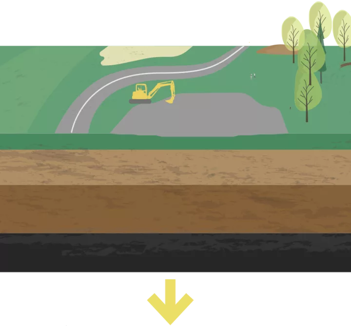
Early & Intermediate Exploration
Field activities conducted during early exploration, such as surveying, rock, soil, and water sampling, rarely result in physical disturbances.
In the intermediate exploration stage, line cutting. excavation of small, shallow pits and trenches, and construction of drill pads and small trails can result in limited, often temporary, land disturbances.
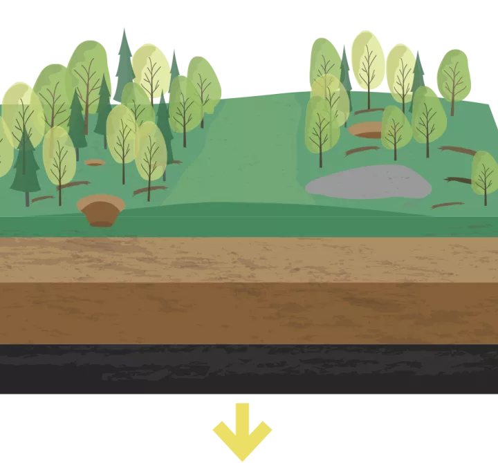
Advanced Exploration
As projects progress to an advanced stage, disturbances increase with the addition of new drill pads, increased mechanized stripping of overburden, and blasting.
Road construction may be required to facilitate bulk sampling.
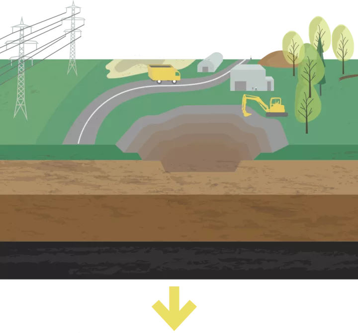
Mine Development and Operation
Mine Development often requires construction of roads, pipelines, and transmission lines to service the mine site. Significant earth-moving work is required to make way for mine facilities, including tailings impounds, and, potentially, open pits. Most of these large disturbances will remain during mine operation. Exploration work may continue within the mining lease or adjacent mining claims, resulting in some additional, limited, disturbances.
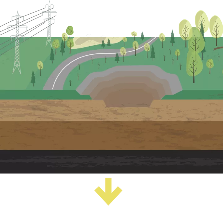
Closure
Can occur following any of the previous stages. In this stage, facilities are removed. Often, economic infrastructure such as roads, transmission lines, and pipelines remain in place to service communities and other economic activities. Tailings facilities typically remain a permanent feature of the landscape. Reclamation activities designed to restore the site to its natural state, including planting of vegetation, refilling excavations, and restoring topographical features are undertaken.
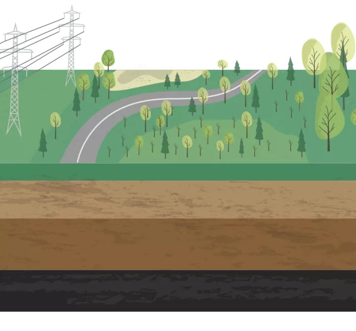
Post-Closure and Reclamation Activities
Focuses on monitoring long-term closure measures to ensure site safety. Routine inspections and care and maintenance of tailing facilities, pit slopes, and topographical features, effluent testing and treatment, and replanting of vegetation may occur over the long-term. However, no additional mining or exploration related disturbances are associated with this stage.
Reclamation activities involve restoring the site to its natural state, including revegetation, recontouring of topographical features, and refilling excavations. Reclamation activities are undertaken progressively at each stage of the project cycle.
Executive Summary of Study
The methodology employs a two-step process consisting first of an initial supervised classification process, in which practitioners train the software to distinguish areas disturbed by mineral development activities from natural features, water bodies, and areas disturbed by non-mining-related activities. Second, in revised classification, the practitioner corrects over or underestimations of disturbance in the initial classification, a process that can be aided with use of site-specific information and subject matter expertise, if available.
In this study, the methodology is applied to eight case study sites, consisting of mineral development projects in the exploration, operation, and closure stages of the mineral development sequence (two sites are currently in the advanced exploration stage, two are operating mines, one is in care and maintenance, and three are closed mines). Together the sites are located across Canada in the arctic, boreal, and hemi-boreal bioregions. Commodities mined or targeted by exploration activities at the sites include gold, silver, copper, nickel, uranium, and platinum group metals. Together the mines selected for study using the methodology consist of both underground and open pit mines.
In this study, the methodology uses medium-resolution Google Earth Imagery (Landsat 5 and Landsat 8) for several time steps for each site as its principle data set. This data was chosen as it offers a consistent set of publicly available imagery for each time step.
The following is a summary of key findings following application of the methodology to eight case study sites:
Comparing Initial Classification to Revised Classification
Revised classification was necessary to correct over and underestimation by the initial classification in the large majority (92%) of cases. Across the eight case study sites, the methodology measured disturbance at 48 time steps between 1984 and 2018. Disturbance estimates ranged from 0.1 km2 for a relatively small advanced exploration site to 26.1 km2 for a relatively large operating open pit mine.
Among the 48 time steps in which in which disturbance was measured, initial classification was more likely to overestimate disturbance than underestimate. In 62% of cases disturbance was initially overestimated, disturbance was underestimated in 30% of cases, while 8% showed no difference in disturbance between initial and revised classification.
For the large majority of time steps (79%), results of initial classification and those of revised classification differed by more than 10%, most of which were overestimates. In absolute terms, initial and revised classification results differed by less than 1 km2 in 46% of cases, by 1 – 5 km2 in 40% of cases, and by more than 5 km2 in 15% of cases, all of which were overestimates.
Effectiveness of the Methodology
The results of the classification, including initial and revised classification, when applied to the case study sites, indicate that the methodology, using medium-resolution Landsat images is effective at identifying and quantifying physical disturbance associated with mineral exploration and mining projects. Classified disturbance includes open pits, surface production facilities, on-site buildings, waste rock storage and tailings facilities, roads, and airstrips. Initial classification is effective at estimating physical disturbance when cloud and snow-free images are available and disturbance features can easily be distinguished from natural features, water, and disturbances associated with other human activities, particularly forestry. In other cases, e.g., when cloud or snow-free images are not available, and in areas with a high level of forestry activity, revised classification, supported by site-specific information and information provided by subject matter experts is necessary to prevent over or underestimates of disturbance size.
Limitations of the Methodology
Notwithstanding the foregoing, the classification process is often unable to distinguish between natural water bodies and on-site water features associated with a mine, such as settling ponds and flooded pits, which can, in initial classification, result in underestimation of disturbance. In two of the case studies, subject matter experts identified the underestimations, which amounted to more than 20% of the total disturbed area.
The classification process, using medium-resolution imagery, is effective at identifying and measuring disturbances associated with advanced-stage exploration projects, including buildings, roads, and airstrips. However, using medium-resolution imagery, the classification is less effective at identifying smaller disturbances associated with earlier stages of the exploration process. Drill pads, cut lines, and small exploration trails, for example, are not easily discerned by the classification using medium-resolution imagery. Many of these features share a spectral signature with natural features, such as wetlands or exposed rock, and forestry disturbances, which can result in overestimations of disturbance following initial training. In addition to using high-resolution imagery, a manualized process consisting of drawing polygons around known exploration-related disturbances, supported by site-specific information, including the location of trails, cut lines, and other disturbance features, would be required to reliably measure early and intermediate-stage exploration disturbances.
The methodology, when applied to a larger sample of case studies, could be employed to develop a credible estimate of the total area of physical disturbance in Canada, or other jurisdictions, attributable to mineral development activities. This effort would benefit from support in the form of an up-to-date database of the locations of exploration and mining sites within applicable jurisdictions.
The methodology could also be applied to estimate physical disturbances associated with other activities, such as forestry, oil and gas development, urbanization, agriculture, and energy corridors, and could be of use to decision makers and stakeholders in measuring cumulative disturbance impacts within regions.
When using medium-resolution Google Earth Engine imagery, the methodology effectively identifies and quantifies physical disturbance associated with built mine infrastructure for open pits, buildings, tailings, waste rock, roads and airstrips. Initial classification can be used to derive estimates of cumulative disturbance associated with built infrastructure at mine sites and revised classification improves accuracy. Overall the methodology can provide a basis for extrapolating to a larger number of sites.
Methodology limitations were observed for the classification of natural water bodies and on-site water features, with the tool experiencing difficulty identifying exploration-related disturbance. This included small exploration-related disturbances, e.g., cut lines and drill pads, that have similar spectral signatures as natural features (e.g., rock outcrops, wetlands) and forestry-related disturbances. Revised classification, employing human intervention, subject matter expertise, mine site plans and historic knowledge is necessary to reduce the margin of error.
PDAC and MAC look forward to the continued application, future use and advancement of the methodology by government, industry and external stakeholders, to better understand true mining-related disturbance. Specifically, the methodology developed can be used as the basis for future research when applied to additional sites in specific regions or across Canada.
Additionally, the methodology can be used to estimate physical disturbance associated with other activities to measure cumulative disturbance impacts within different regions and sectors such as forestry, oil and gas development, urbanization and in the development of energy corridors.
The Study is an introductory effort on a subject that only scratches the surface of a much larger research opportunity. As a starting point, the study methodology provides an objective way to assess and calculate physical disturbance and can be used to make evidence based land management decisions.
We hope to see the methodology adopted and applied across additional project sites. We welcome the opportunity to partner with government, NGO’s or private sector organizations to further develop and apply the methodology. If you have an idea to expand or continue the use of this methodology, please get in touch with the study researchers.